
|
Recently, there's been a troubling spike in emergency incidents and if hikers don't step up their game, more people are going to get hurt or worse. Fortunately, you're reading the ultimate, cut the crap guide to hiking Half Dome in Yosemite National Park. Here you'll find everything you need to hike to this iconic summit including crucial permit information information, training, trailheads, tips and far and away the best videos of the trail to be found anywhere. Enjoy, and stay safe out there! The absolute best video guide to hiking Yosemite's Half Dome. The trek to the summit of Half Dome is easily Yosemite's most famous trail, and consistently listed as one of the "best" and/or "most dangerous hikes" in the world. Or as one writer for National Geographic put it “the hike you’ll talk about as all others fade into pleasant memories.” While that's a bit hyperbolic, those who have made it to the summit will tell you, Half Dome is special and offers hikers a unique and iconic experience. Just make sure you're ready. Preparation“One does not simply [hike Half Dome]”. Due to the trail’s difficulty and popularity, successfully reaching the summit requires more planning and foresight than just throwing some snacks into a backpack and lacing up your hiking boots. Red Tape Crowd pressures, coupled with trail limitations, safety concerns and the Park Service’s charge to preserve and protect Yosemite landscape has given rise to a sometimes controversial permit system. Without a permit, you will not be permitted past the base of the subdome between May and November where park rangers check permits and IDs. Ascending the subdome and cables without a valid permit can result in a fine of $5000 and even jail time. Without a permit, your dream of reaching the summit will remain exactly that. So, Item number one on your to do-list is to apply for a permit (day and overnight options available). 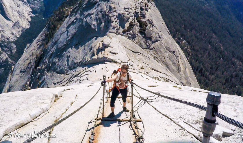 Ascending the Half Dome Cables. How to apply for a permit During the peak season (generally between Memorial Day and the second Monday in October), “a maximum of 300 hikers per day are allowed” access to the subdome, cables and summit. These permits are split between day hikers (225) and backpackers (75). Plan ahead and decide if you’d like a day permit or an overnight wilderness permit. To improve your chances, avoid weekends and holidays if at all possible; and if your schedule allows, apply for a range of days rather than a single day. If your schedule is flexible you’ll greatly improve your chances of scoring a permit. For a breakdown of days with more favorable odds, click here. Day hike permits (lottery only) To apply for the day hike permit lottery go to recreation.gov between March 1st and March 31st, submit your application for a maximum number of six day-hiking permits and pay the $10 non-refundable application fee. Only one application per person is allowed, “additional applications will be voided without refund”. You'll recieve an email in mid-April with lottery results. Backup: Depending on the number of remaining or canceled permits, around fifty day-hike permits will be distributed via a daily lottery during peak season. If you draw a zero from the March pre-season lottery, you may apply for the daily lottery at recreation.gov. (Important) Daily lottery applications must be submitted two days before your intended hike date. Hiking to summit during the offseason is allowed without a permit. But, if attempting a pre or post season ascent, be advised that the cables will be “down”, meaning the steel posts have been removed. This makes the ascent more difficult and dangerous. Addition climbing gear and mountaineering experience is strongly recommended. 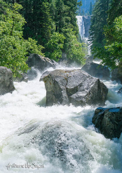 Wilderness or Backpacking Permit Reservations (lottery/first come) Applications for wilderness permit reservations are accepted beginning 24 weeks before your intended start date and are submitted through recreation.gov. Forty percent of wilderness reservations are held in reserve and become available seven days before the intended start date (Your application must be completed three days before your intended start date. Any left over wilderness permits are available on a first come first serve basis. But few if any permits will be available on any given day. If you wish to summit Half Dome as part of your backpacking itinerary, you must request the addition of a Half Dome specific permit to your wilderness permit. This can be done when applying for your wilderness permit, or when picking up your backcountry permit at the wilderness office. An additional $10 fee separate from your wilderness reservation fee will be added for each Half Dome permit issued. In order to add a Half Dome permit to your overnight wilderness permit, you must begin your trek at one of seven trailheads. All three trailheads highlighted in this guide are included on that list. Unlike day hike permits which are only valid for a single specified day, wilderness permit holders who have added a Half Dome permit may access the cables and summit on any date listed on their wilderness reservation permit. This offers backpackers additional flexibility. For more details click here: www.nps.gov/yose/planyourvisit/hdwildpermits.htm DifficultyDifficulty is a relative concept which varies drastically from one hiker to the next depending upon both fitness and hiking experience. That being said, even veteran hikers can find themselves in distress when ascending or descending Half Dome. Do not underestimate this hike. At 14 or more miles round trip, and a minimum of 4800 ft of ascent, Half Dome is considered the most strenuous day hike in vicinity of Yosemite Valley. DO NOT attempt this hike without sufficient physical preparation or inadequate gear and seriously consider consulting a physician before attempting. Mere mortals will require 10 or more hours to complete the shortest route (Yosemite Valley via The Mist Trail). Begin your hike early in the morning (possibly well before sunrise) and plan on finishing in the evening. Whether you're planning on completing the whole trek in one day or as an over-night excursion a flashlight and/or headlamp should without question be included with your gear. Record runoff on the Mist Trail in 2023. You've never seen a Mist Trail video like this. SafetySince 1930, the Mist Trail to Half Dome Route has claimed more than 60 lives. This is an especially hazardous trail for inattentive or foolhardy hikers and for obvious reasons. While the permit system, implemented in 2010, has reduced crowds on the subdome and cables by 66% there has been no corresponding drop in injuries and deaths. Water: Second only to car accidents, water hazards are Yosemite’s leading killers. The jaw-dropping waterfalls that punctuate Yosemite’s dream-like landscape have and will continue to remorselessly and brutally punished visitors who fail to exercise caution near whitewater and waterfalls. The Mist Trail alone keeps Yosemite Search and Rescue busy, responding to an average of 100 incidents a year. Take deliberate steps, wear quality hiking shoes, with good traction and ankle support, and exercise extreme caution near rivers and waterfalls — especially during spring and summer runoff. Tennis shoes are not appropriate. Just days before my wife and I made this trek in 2017, a local jogger slipped and fell along a portion of The Mist Trail and disappeared into the raging torrent beneath. A week later The Park Service was still looking for his body. Lives are lost every year because hikers fail to take the proper safety measures or become complacent near Yosemite’s rivers and waterfalls. You cannot swim in highly oxygenated whitewater. Weather: Daytime temperatures regularly reached 90+ Degrees Fahrenheit. Travel smart and intelligently manage your fuel and water intake throughout the day. You can learn more about water and fuel management by watching my rim to rim video series by clicking here: www.youtube.com/playlist?list=PLdRPR_VkYdYV9X-jOplYQG8duciJZIF4W. Travel when possible in the morning or evening hours to beat the heat during the hot summer months. That being said, due to the time needed to complete this trail (10+ hours) plan on hiking in hot conditions if visiting in the summer. Water features can offer some relief from the heat, but as mentioned above they can also be quite dangerous. Use good judgment and err on the side of caution. Adults should drink one gallon (4 liters) of water when hiking Half Dome. The last reliable filterable water is located along the Merced River in Little Yosemite Valley near the backpackers' campground. Do not proceed past this point without enough water for everyone in your party. Switching now from hot to cold, early mornings along The Mist Trail can be extremely frigid. Even on warm days The Mist Trails ice-cold namesake is impossible to avoid during peak runoff. Bring a jacket and waterproof layer or take the detour along the John Muir Trail to keep dry. If you feel your core temperature drop and you can’t warm up in the sun, keep moving. Without external warmth, you’ll need to generate your own. As always, your best option is to be prepared. Finally (as far as weather is concerned), remain aware of potential storm systems – especially when near the subdome, cables or summit. Lightning has claimed the lives of numerous individuals and injured many others on Half Dome’s subdome and summit. If stormy conditions are likely, turn back and get to lower elevations quickly. If you see dark clouds or hear thunder, do not take shelter on the summit or the subdome. Start your descent immediately and get to a lower elevation as quickly and safely as possible. Should you find yourself in a dangerous situation, stay calm but move deliberately while remaining aware of changing conditions and potential dangers such as rainfall, which can make granite extremely slippery and result in traffic jams and hazards on the cables and elsewhere along the trail. 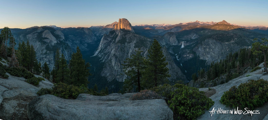 View of Half Dome from Glacier Point Drop-offs: The trail to the summit of Half Dome brings you into close proximity to some breathtaking drops. If you are extremely averse to heights, you may want to reconsider attempting to summit Half Dome. Exercise caution near ledges or cliffs. Falls from these dizzying heights are nearly always fatal. For your safety, stay on the trail and help prevent erosion, as well as trail and vegetation damage. WildlifeBlack Bears: Bears are the animal most people think of when it comes to wildlife safety and with good reason. Yosemite National Park has made great strides over the past decades to counter years of poor bear policy and practices. That being said bears represent minimal risk to responsible hikers. Stay aware of your surroundings, store your food properly and hike in groups. If you encounter a bear, do not let it obtain human food and DO NOT RUN. Stand your ground, make noise and group together until the bear leaves. In the extremely unlikely event that a bear does attack, fight back and stay on your feet. Do not play dead. Playing dead is the last resort if attacked by a grizzly bear. Grizzly bears were driven to extinction in California nearly 100 years ago when the last know California Grizzly was shot outside the park in the 1920s. Any bear encounters should be reported to park rangers. (Important note on bear deterrents) Bear spray is not permitted in Yosemite National Park. Firearms are permitted as long as the carrier complies with all federal, state and local laws. “Discharging a firearm for any reason is illegal” within the National Park. 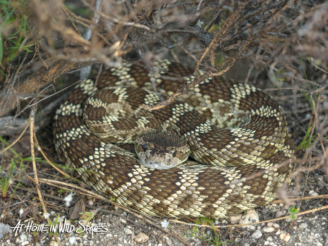 One of three rattlesnakes we encountered near Little Yosemite Valley during our hike up Half Dome in 2017. Rattlesnakes: Yosemite National Park is home to the Northern Pacific Rattlesnake. Although unlikely, it is quite possible to encounter one of these venomous snakes along the trail. If you do encounter a rattlesnake, give it plenty of space. Snakes only strike if they feel threatened. Given space and time, they will move out of the way. Inform any nearby hikers if you spot a rattlesnake near the trail. If you or someone in your party does receive a bite, remain calm. Here’s what to do— and not do: -Call 911 inform the dispatcher of the injury and your location. -Remove any rings, watches or tight clothing near the bite site as swelling will occur. -Gently wash bite and mark with a pen or marker if available and note the time. -Limit motion. Either wait for emergency personnel or carry bite recipient down trail. -If you are by yourself and/or unable to contact emergency personnel, continue at a steady pace to the trailhead. -Do not try to catch the snake. -Do not cut or suck on the bite site. -Do not wrap with a bandage or tourniquet. What’s important is reaching medical help as soon as possible. (Note) Roughly 25% of rattlesnake bites are "dry bites", meaning no venom is injected. Symptoms of envenomation include pain, burning, nausea, muscle twitches, swelling, and damaged tissue. Even if you don't immediately experience these symptoms you should still seek medical attention. Squirrels, marmots, chipmunks, etc: As strange as it may sound, of all the animals in Yosemite, the creatures most likely to do harm to people are generally seen as the least threatening. Squirrels, chipmunks and other rodents inflict the park’s most recurrent injuries, mostly in the form of bites. But they have also on occasion transmitted diseases such as the plague. It should go without saying, but do not feed, approach or harm any animal within the park. Beyond placing yourself and the animal in danger, you can also be slapped with a hefty fine. When it comes to wildlife, admire them from a distance. Safety is ultimately about situational awareness and appropriate preparation. Hike responsibly and stay safe. View of Half Dome from Glacier Point. Yosemite Valley to the left. Vernal and Nevada Falls (path of The Mist Trail) visible to the right. Routes and Trailheads
The CablesUntil 1875 when George G. Anderson became the first known climber to reach the summit, Half Dome was believed to be “perfectly inaccessible”. — No more. The cables are arguably the trail’s most technical and challenging section and should not be taken lightly. Ascending the final 400 vertical feet at a 50-degree angle along the cables is a full body workout. Make sure to savor the experience, but don’t become complacent in the process, missteps can be and have been deadly. The majority of falls from Half Dome occur along the cables. And the majority of those falls occur when the victim was descending the cables. NBC Nightly News contacted me to discuss the perils of the cable route following the tragic death of Danielle Burnett who slipped and fell in September 2019. I tell you what I told them. This trail is no joke and the granite along the cables is slick and potentially perilous under the best of circumstances. Make double sure your gear is properly secured before ascending or descending the cables. If something falls, you're not getting it back. Given the limited space on the cables and the fact that worn granite and perilous drop-offs are constant companions, it is essential to remain courteous, patient and cautious. Avoid pulling the cables away from the mountain as the steel posts propping them up are not anchored to the mountainside. Do yourself a favor and bring your own well-fitted gloves with good grip. After descending the cables take your gloves with you. Do not leave them at the base of the cables. The use of safety lines while historically popular is currently discouraged by the park service. Having hiked Half Dome before and after this change in guidance, expect traffic to move slower. There are a great many people who attempt to summit Half Dome who are not mentally or physically prepared for the cables, and without an anchor system, traffic often slows to a total stand still. Safety lines definitely slowed traffic before, but now days, anxious hikers are known to freeze and stop traffic completely. This is not the place to make a scene or rush someone who is freaking out. Communicate respectfully, and be encouraging. Patience and respect are ESSENTIAL when on the cables. No exceptions. 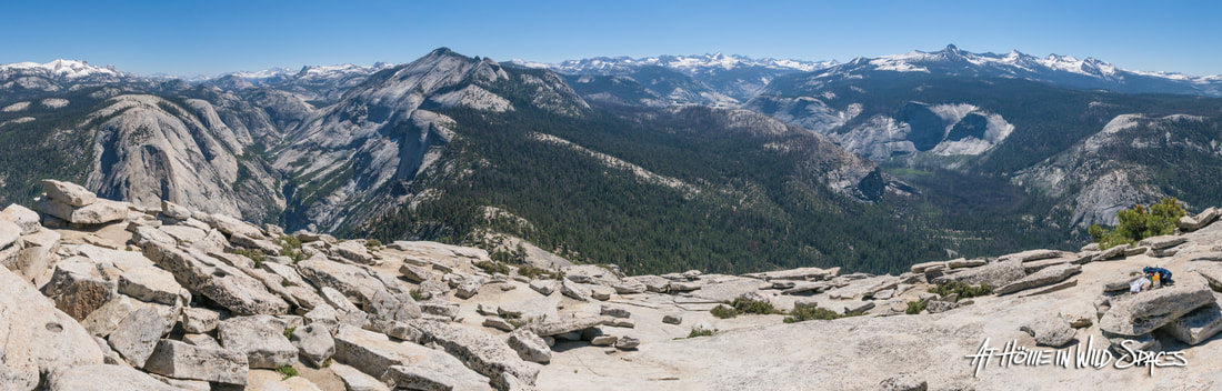 Panorama from Summit of Half Dome. North Dome to the left, Clouds rest left-center and Little Yosemite Valley to the right. Other Important InformationBathrooms and Water locations (Yosemite Valley Route): Happy Isle Trailhead (flush toilets, tap water, and plumbing) Vernal Fall Footbridge (pit toilet, last available tap water, and plumbing) Emerald Pool Just above Vernal Fall (pit toilet) Above Nevada Fall (pit toilet) Little Yosemite Valley Backpackers Camp (composting toilets) Bathrooms also available at Glacier Point (Panorama Trail) and Tenaya Lake (Sunrise Trail). If you are unable to reach one of these toilets before (cough)— zero hour, “deposit solid human waste in a cathole dug six inches deep at least 100 feet from water, camp, and trails”, and “cover and disguise the cathole when finished. Pack out all toilet paper (even used), garbage and hygiene products. Why? As stated above: This is an extremely popular trail in one of the world’s most popular parks. Thousands of people from all over the world use these routes every day and any waste or garbage, if not disposed of properly will quickly accumulate and degrade the experience and the landscape for others. Be responsible and preserve the landscape and experience for others. Souvenirs “Take only pictures, leave only footprints.” More than a catchy saying, it’s the law. Removing anything besides lawfully obtained souvenirs from a gift shop, whether rock, plant, animal, artifact, etc… is illegal and carries hefty fines and even jail time. With the exception of garbage, leave everything exactly as you found it. Final SuggestionObtaining any permit for Half Dome is a sweet, sweet deal. However, in my opinion — You simply can't do better than a wilderness permit. Not only do you get to spend one or more nights in the backcountry, but a wilderness permit is valid for any day of your backcountry trip, which gives you flexibility not enjoyed by day hikers.. Too often people treat hiking like a trip through a fast food drive-through. In and out and on their way. Yosemite's backcountry is a banquet for the spirit and the senses — Don't rush it any more than you have to— Savor it. There you have it! You should have all the essential information you need to successfully reach the summit of Half Dome. Did we miss anything? Make sure to come back and share your experience in the comments below along with any tips on how to prepare for Half Dome. Want more?
2 Comments
Two weeks ago, Danielle Burnett became the third person in nine years and the second since May 2018 to fall to her death while on Half Dome's precipitous cables. Yosemite alone averages close to 17 deaths a year, and the U.S. park system as a whole averages six deaths a week. What's causing these deaths, and what is there to learn from tragedies like the one that claimed Danielle's life? 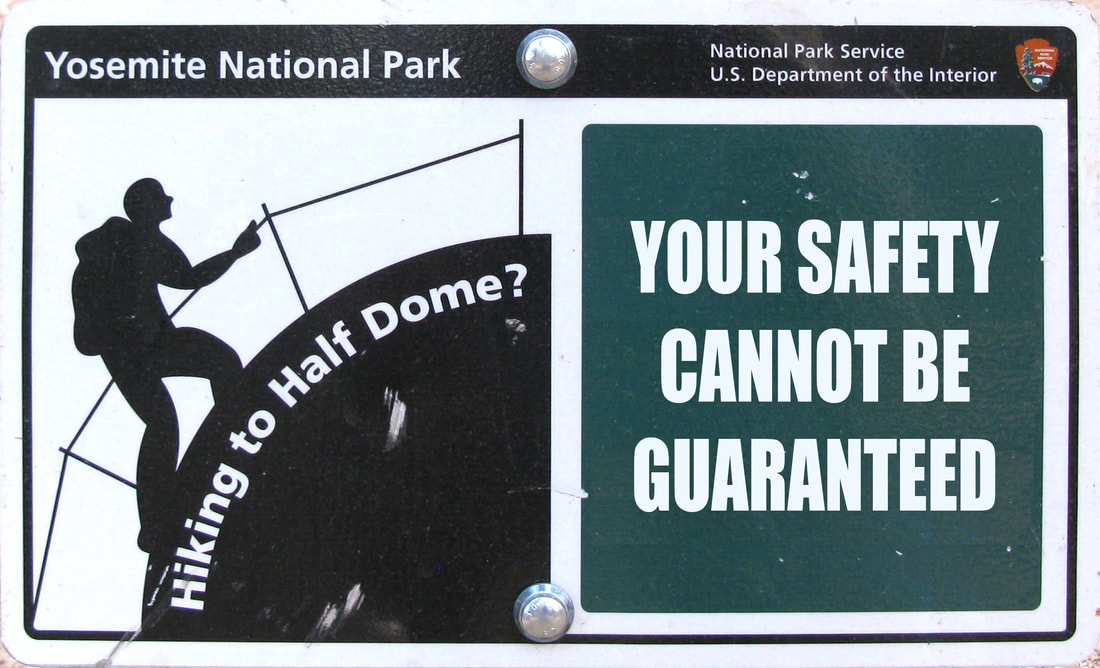 Some in the outdoor community may see Danielle's fate among others as the result of careless behavior, broadly classifying victims as reckless selfie-takers or inexperienced couch potatoes who got overly excited after learning about Half Dome on social media. But, if we think all accidents are the result of social media fads, or inexperienced wannabes attempting things they shouldn't be — we're dead wrong. Clearly, there are more than a few cases where painfully irresponsible behavior has led to death, injury and damage to natural resources. Whether taking selfies near a cliff's edge in Yosemite National Park, crowding bison in Yellowstone, or YouTubers who made international headlines in 2016 by damaging Yellowstone's wondrous Grand Prismatic Spring then achieving double infamy in 2018 when three of their members were killed after swimming in a treacherous pool above Shannon Falls in British Columbia.  Clearly, far too many travelers are using poor judgment and taking foolish risks. But more often then you would think, victims are not novices exploring the outdoors on an internet-inspired whim. Rather, they're often well-traveled explorers who despite their experience, are getting into trouble. How then do we make sense of so many veteran hikers getting into trouble? What is there to learn, or relearn following tragedy? Lesson #1 - Nature Sets the RulesThe first and frequently discarded lesson is that Mother Nature sets and enforces the rules; we abide by them. If these terms are not acceptable to you, please — stay home. Though not always the case, she can punish foolishness, complacency, and disrespect harshly. Remain mindful of potential hazards, and don't tempt nature to remind you who is in charge regardless of your experience level. In many cases, missteps don't allow for do-overs. While nature can seem unforgiving, she's also more than happy to reward preparation and humility. Do everything you can to remain in this second group. Lesson #2 - You are responsible for your own safetyIt never fails, after each tragedy, some people begin to question, "Why are people allowed to hike this trail?" Others declare, "There should be railings." and on and on. If you ask me, there are already far too many railings. Land managers work constantly to warn the public about potential hazards or destructive practices and even at times provide barriers. But you and you alone are responsible for your safety. Spending time outdoors brings with it certain hazards, as does driving on the road. Statistically speaking Yosemite's roads are far more dangerous then Half Dome's cables. Should we close the roads? No, that would be ludicrous. Instead, we take reasonable steps to mitigate dangers the same as we do on roadways. We wear seatbelts, remain attentive and courteous, and we alter itineraries if necessary. As for railings: they have their place. But to place railings along every inch of Yosemite's rim or wherever a fall is possible, would in my view be criminal. I've never encountered a railing that didn't detract from the scenic beauty and natural character of a wild landscape. Every reasonable effort should be made to keep people safe, but railings can't replace personal responsibility. Situational awareness, preparation, and good judgment are infinitely more effective than railings. We've already changed and in many ways tarnished these priceless islands of natural wonder and beauty. It's time we calibrate our behavior, prioritizing preservation over alteration. Make use of the resources provided by the National Park Service, Forest Service, BLM, State, municipal, and private land managers. Lesson #3 - Monkey See, Monkey... If you spend much time outdoors, you've seen this tiresome, frequently destructive, and often dangerous scene play out again and again, and again. One person does something, and others quickly follow suit. The internet age has exasperated the problem, with hordes of people desperate to achieve internet fame or simply replicate something they saw online, even if it's illegal and/or dangerous. Whether rope swings from arches, dramatic selfies on Instagram, or watching someone take unnecessary risks in person — don't participate in reckless or destructive behavior, even if other people are doing it. Exploring the outdoors packs more than enough thrills without requiring foolishness or cheap sensationalism. Unfollow or unsubscribe to individuals or content creators that subsist on sensationalism and hazardous, irresponsible stunts. If necessary, report them to the proper authorities. It's not just their life, others are almost guaranteed to follow. Lesson #4 - Survival is Not Proof of CompentencyFrom all accounts, Danielle was a seasoned and competent hiker, as were a number of those who have met a similar fate on Half Dome. All the factors that lead to tragedy in the backcountry are not always known or understood. There is a natural temptation to speculate and fill the blanks. Inventing a narrative that suits our world view might satisfy our desire for answers, but more often than not — we're fooling ourselves. According to one account, not even people who witnessed Danielle's final moments know exactly what led to her fall. Those of us who weren't present would be wise to suppress the impulse to speculate. Instead, we should reflect on how even the most experienced of us needs to prepare and remain attentive. Last October, I was exploring the Wasatch Mountains when the weather turned and I decided to call it for the day. While taking some quick photos I spotted a helicopter hovering within feet of sheer cliffs in a snow storm. It was clear authorities were searching for someone. A seasoned hiker and traveler had vanished a month earlier while hiking one of his regular trails. I was there when they found his body. Not everyone who pets a bison gets gored. Not everyone who puts themselves or others in danger for an ill-conceived selfie gets killed, not everyone who hikes Half Dome's cables in a rainstorm falls to their death, nor do competent or experienced hikers always make it home. Following Danielle's accident, I was fortunate to discussed visitor safety with Scott Gediman, Chief Public Affairs Officer for Yosemite National Park. While he couldn't discuss the details surrounding Danielle's specific case, we did discuss safety concerns and the Park Service's efforts to help visitors prepare and have a safe and enjoyable trip. Entering restricted or hazardous areas and taking risky selfies have clearly been responsible for a number of tragedies, but Ranger Gediman added that "Between 4-4.5 million people visit Yosemite National Park every year, and the huge majority have a wonderful visit. However, there are occurrences when people are doing all the right things and something happens." Adding, "You're entering a wild place, that's why we are so dedicated to providing safety information and helping visitors get the tools they need." Lesson #5 - Summit Fever KillsSome have suggested that the introduction of the permit system in 2010 may have made Half Dome more dangerous, concluding that hikers might see their allotted day as their "one chance" to reach the summit. Summit Fever or the intense drive to reach your destination is nothing new. All hikers and climbers need to stay mindful of its pull. Permits, time, effort, expense or the chance to add a checkmark to your bucket-list should NEVER dictate your decisions in the backcountry. Weather and other environmental factors, your fitness (including mental and emotional condition), preparation, the condition of your gear and backcountry ethics are the only factors that should influence your decisions. Don't let Summit Fever and gambling psychology enter your decision making.  The trail to Half Dome's summit is a positively stunning hike and one of our favorites. Thanks to the cable route, you don't have to be an expert rock climber to experience the sprawling view from the summit. But do not take this trail for granted. Even seasoned hikers need to prepare and watch their step. That being said, the cables have not proven to be especially deadly. While absolutely tragic, three deaths in nine years are not many. Other trails including Half Dome's less famous first half, The Mist Trail have proven to be significantly deadlier. Where ever you travel, you are your own best guarantee. There's no substitute for situational awareness or good sense. Use the resources provided by park managers and read our comprehensive guide to Half Dome and consider the lessons listed here. More from athomeinwildspaces.com
The National Park Service turns 103 today! In their honor, I've compiled a list of 10 reasons why our national parks, despite crowds and growing pressures, are still as awesome as ever. So get ready, as we dive into what is best about our amazing national parks. 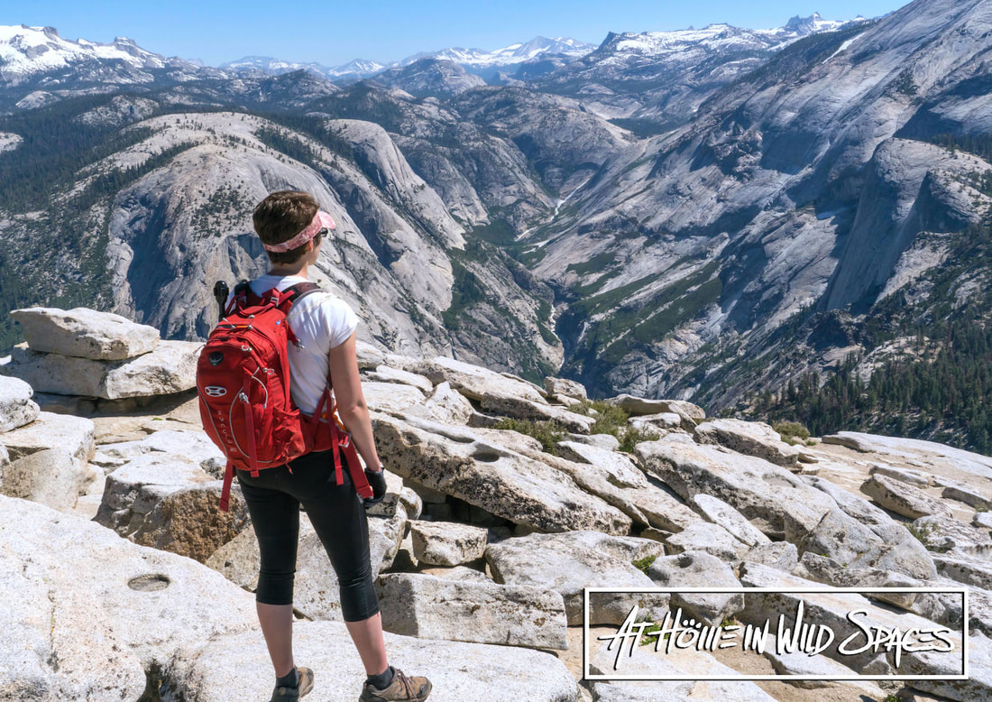
|
|||||||||||||||||||||||
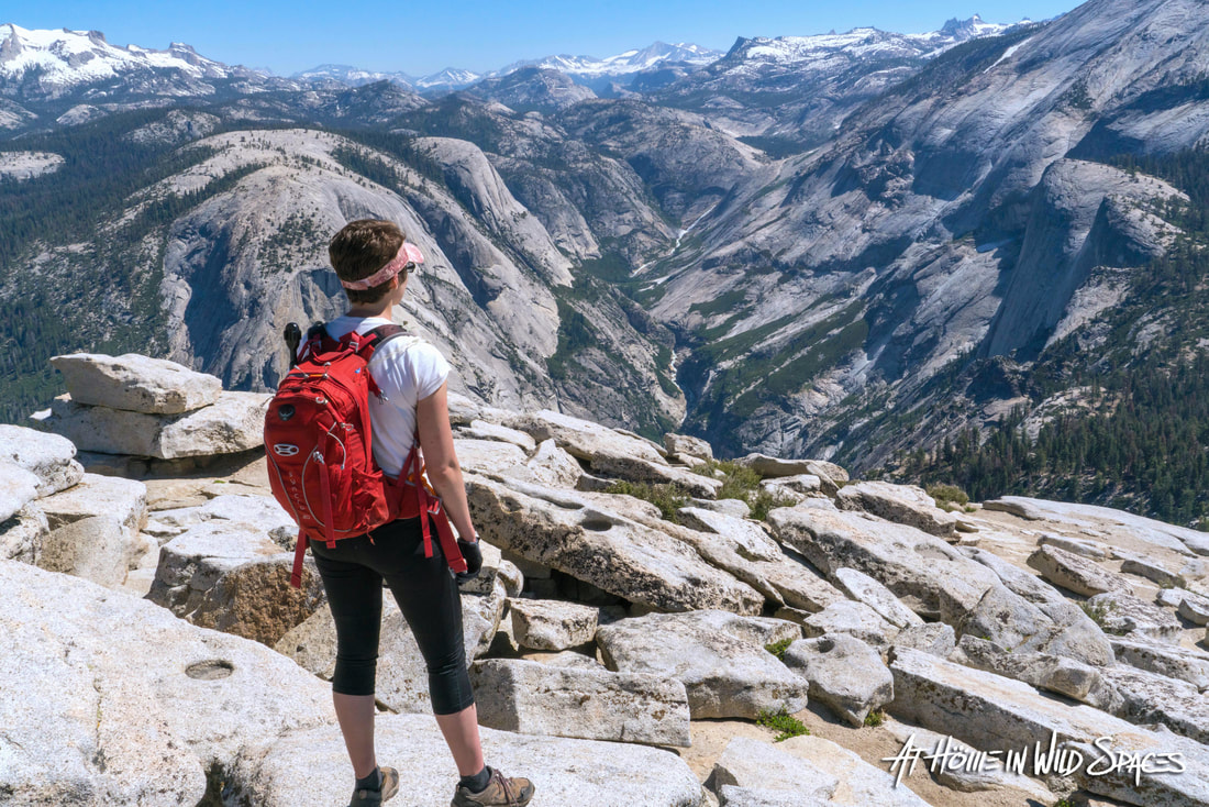
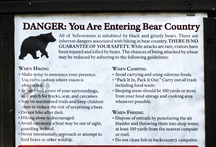
Photo: Northern boundary of the 2016 Bears Ears National Monument designation as viewed from Dead Horse Point State Park. By At Home in Wild Spaces.
Utah – A month of hindsight is a valuable thing. With a new year now underway, let's examine what we know concerning the legality of last year's reductions to Utah's national monuments and discuss how the issue may develop in 2018.
The question where it all begins: Were President Trump's December reductions even legal? Answer: Undetermined
The argument for the legality of President Trump's monument reductions is relatively simple and based on two claims.
Claim #1-The Antiquities Act grants the President discretionary authority to both designate new monuments and alter or revoke previous designations.
Claim #2 - There is precedent.
So how well do these two claims hold up to scrutiny? Answer: Not great.
The Antiquities Act gives Presidents authority to create national monuments on federally owned land at their discretion, but says nothing of altering or revoking previous designations. Ultimately, all hope for the long term legitimacy of President Trump's monument reductions rests on the question of precedent.
There have been at least 19 occasions where past presidents have amended monument boundaries by executive action, but this is where support for Trump’s cuts gets, well... problematic.
Historic monument alterations by presidents weren't necessarily reductions. For example: On August 14, 1962 President Kennedy signed a proclamation declassifying 320 acres of Utah’s own Natural Bridges National Monument, also adding 5,236 acres to the monument. Other alterations addressed oversights in previous designations where private property had been included within the original monument.
This all begs the question: What criteria, if any, must be met before President’s may alter existing monuments? Again, on these questions The Antiquities Act is completely silent.
While there are some clear examples of a one or two relatively moderate reductions, generally speaking alterations have been both minor and infrequent. President Trump's reductions on the other hand are frankly – unprecedented. His Dec 4, 2017 proclamations shrink Bears Ears (originally 1.35 million acres) by 1.15 million acres, and Grand Staircase-Escalante (1.9 million acres) by nearly 900,000 acres.
Historically, presidential reductions to monuments rarely affected more than 800 acres, less than one thousandth of Trump's reduction to Grand Staircase. The largest historical monument reduction occurred in 1915 when President Wilson, claiming the timber was needed for the war effort in Europe reduced Mount Olympus National Monument by 313,000 acres, a reduction that went unchallenged in court as did FDR's 72,000 acre reduction of Grand Canyon National Monument in 1940.
President Trump’s Dec 4th reductions alone strip monument status from 2 million acres: nearly four and a half times the 461,000 acres removed from national monuments by all of Trump’s predecessors – combined. And unlike the now relatively moderate reductions to Olympic and Grand Canyon, Trump's reductions were immediately met by a cascade legal challenges.
Finally, there is the Federal Land Policy and Management Act of 1976 to consider. Passed since the last presidential monument reduction in 1964, granting congress power and influence over national monument management decisions.
Photo: Sunrise looking East from Bears Ears National Monument. By At Home in Wild Spaces
So what does this all mean for 2018?
Since past reductions went unchallenged, the question of legality is being argued into a void. There is no clear answer as of yet whether the President's discretionary power to designate monuments also extends to altering or diminishing designations.
President Trump's proclamations are set to go into effect in early February; 60 days after they were signed. If one of the various courts now considering challenges to the President's reductions were to rule against them, implementation of Trump's proclamations would likely be held in legal stasis until a final verdict is made.
The ultimate question of legality may well be decided by the U.S. Supreme Court, though not likely before years end. Whenever the decision comes, it's guaranteed to be historic.
And then there's the question of congressional elections. Can or would congress throw its hat into the ring with legislative measures to support or overturn the President's monument reductions? Utah's delegation has already put forth legislation that would, if passed, make the reductions permanent and transfer some ex-monument lands to the state of Utah.
What do you think? How and when will the fate of Bears Ears and Grand Staircase-Escalante National Monuments be decided. Make sure to leave a comment below and share.
 RSS Feed
 More from At Home in Wild Spaces
Preface: This article was written for and initially approved for publication by KSL.com (Utah's largest news organization). Plans for publication were however abandoned by management believing it "might cause friction" with the Deseret News (KSL's sister company), which published Governor Herbert's op-ed, 5 myths about bears ears on Dec 4th, 2017.
It is not the purpose of this article to attack the Governor or the Deseret News, but to make an independent and fact-based assessment of claims made in Governor Herbert's Dec 4th op-ed.
It is not the purpose of this article to attack the Governor or the Deseret News, but to make an independent and fact-based assessment of claims made in Governor Herbert's Dec 4th op-ed.
Photo courtesy of Geoff and Jamie Harmon.
December 4, 2017 – Following petitions by Utah's congressional delegation, the Utah state legislature and Utah's Governor Gary Herbert to shrink or rescind Grand Staircase-Escalante and Bears Ears National Monuments, President Donald Trump signed two presidential proclamations slashing monument status from 2 million acres previously designated by Presidents Bill Clinton and Barack Obama.
Immediately following the reductions, Utah's Governor Gary Herbert published an article in the Deseret News in which responds to what he calls 5 "myths" relative to the debate over Bears Ears National Monument.
What follows is a fact-based assessment of the arguments put forth in Governor Herbert’s op-ed 5 myths about Bears Ears. The Governor’s response to each "myth" will be rated as True, False, Problematic, Undetermined or Misleading. Due to the layered nature of the Governor's claims more than one verdict may be rendered.
(Note) For reasons not explained by Governor Herbert, his article omits any mention of Grand Staircase-Escalante National Monument. Since both Bears Ears and Grand Staircase-Escalante National Monuments were altered in parallel, this article will assess the governor’s claims as they relate to both monuments – not just Bears Ears.
“Myth” #1 according to Gov. Herbert: By reducing the size of BENM, these federal lands will be transferred to the state of Utah and/or private entities.
The Governor’s response: BENM was designated on federal lands that will remain under federal ownership regardless of monument status. Interior Secretary Ryan Zinke has adamantly opposed the wholesale transfer or privatization of federal public lands, and that commitment is reflected in this modification of monument boundaries.
Verdict: Undetermined/Misleading.
While it is true that President Trump’s proclamations do not transfer ownership of any federal land to the “state or private entities”, it is also true according to Article IV Section 3 of the U.S. Constitution that Congress, not the president – makes all determinations regarding the sale or transfer of federal land. Secretary Zinke’s personal persuasions as cited by Governor Herbert do not dictate decisions concerning the sale or transfer of federal lands.
The Governor’s claim that monument lands won’t be “transferred to Utah/or private entities” must be rated as undetermined since removal of national monument status now allows for that possibility. And given Governor Herbert's own efforts along with Utah's congressional delegation and other state leaders to compel the federal government to relinquish ownership of more than 30 million acres of federal lands to the state of Utah, the Governor's claims must also be rated as misleading.
See also Transfer of Public Lands Act, Utah Public Lands Initiative, Utah Enabling Act Litigation and Utah H.C.R.1.
There is little to no evidence to suggest Utah's political leaders won't pursue State ownership of previous monument lands. Quite the opposite. Shortly after President Trump’s cuts to Grand Staircase and Bears Ears, Utah’s Representative Chris Stewart introduced new legislation that would, if passed by Congress, transfer former monument lands to the state of Utah.
Governor Herbert’s own public statements supply further uncertainty regarding his claims about the fate of declassified monument lands should the state acquire them, having state previously, “liquidating” federal land is an idea “worth exploring”, adding, “I would argue we could privatize public land and have it developed commercially…"
Sunrise from Bears Ears. Photo by At Home in Wild Spaces.
“Myth” #2 according to Gov. Herbert: Without national monument status, the vast landscape of the Bears Ears region will be subjected to unchecked exploitation.
The Governor’s response: Before Obama’s monument designation in December 2016, the Bears Ears region was mostly federal public land subject to a network of federal protections that conserve the area’s natural beauty and archeological treasures. Trump’s reconfiguration of the monument’s boundaries does not change the federal ownership of these lands and maintains the existing system of federal protections.
The Governor then cites the Dark Canyon Wilderness, and a number of the “wilderness study areas” which he claims “ensure the integrity of beautiful scenic vistas”, by prohibiting activities like, “motorized travel or natural resource extraction”.
Verdict: True but Problematic
The Governor is right that before Bears Ears and Grand Staircase were designated as monuments there were protections already in place like The Archaeological Resources and Protection Act, prohibiting looting or vandalism of archaeological sites and artifacts.
Each land management agency also has authority to enact and enforce protective policies and regulations governing both recreational and commercial use of public lands. There are however limits and susceptibilities within the protections cited by the Governor.
The Governor’s reference to Wilderness and Wilderness Study Areas is one such example. The Wilderness Act authorizes Congress to designated wilderness areas, which as the Governor claims permanently prohibit all motorized vehicles and natural resource extraction. Wilderness Study Areas or WSAs on the other hand are only managed as wilderness until Congress makes a determination on whether or not to grant them full wilderness status. They are not permanently protected.
The 43,353-acre Dark Canyon Wilderness is the only congressionally designated wilderness within the original Bears Ears National Monument, and protects a mere 3% of the land affected by the Obama era designation. Unless granted full wilderness status the eleven Wilderness Study Areas cited by Governor Herbert, only temporarily protect 381,000 acres (roughly 28%) of the 2016 Bears Ears designation from motor vehicle use and natural resource extraction.
Without monument protections the remaining 69% of the Bears Ears region remains susceptible to both motorized travel and natural resource extraction, as might portions of the eleven wilderness study areas if not granted full wilderness status.
Grand Staircase-Escalante contains twelve WSAs and no designated wilderness areas.
Finally, less than 10% of the more than 100,000 archaeological sites within Bears Ears have been formally surveyed. Archaeologists and Paleontologist alike have expressed concern that removal of monument status has compromised the safety of what has been called one of the countries largest stores of historic and prehistoric treasures.
Photo courtesy of Geoff and Jamie Harmon
“Myth” #3 according to Governor Herbert: Without national monument status, the Bears Ears region will be crisscrossed by coal mines, oil rigs and gas pipelines.
The Governor’s response: Mineral resources beneath Bears Ears are scarce. There is no developable oil and gas. The region’s nonrenewable resources, including uranium near the Daneros Mine, were actually outside the expansive monument boundaries declared by Obama. The integrity of the Bears Ears landscape, long kept intact before the creation of the monument, will almost certainly remain intact after Trump’s announcement. And to ensure this going forward, the state of Utah is asking for congressional legislation that will exclude the region from mineral extraction.
Verdict: False/Misleading/Undetermined
The “myth” as presented by the Governor is somewhat hyperbolic, but the governor’s claim that “(There) is no developable oil and gas” is incorrect. While there is some debate over the practicality of mining or energy extraction within much of the Bears Ears National Monument region, the USGS concluded the Paradox Basin (much of which was protected within Bears Ears NM) contained an estimated “89 million barrels of oil, 833 billion cubic feet of gas, and 18 million barrels of natural gas liquids”.
Since 2013 the oil and gas industry has in fact lobbied the BLM for access to more than 100,000 acres of land inside or within one mile of the Bears Ears NM. According to the BLM, “There are 23 existing federal oil and gas leases either partially or wholly located within the Bears Ears National Monument” as well as dozens of active and inactive oil, gas and mining (including uranium mining) operations.
While, there are different views about how accessible the natural resources may be within Bears Ears National Monument the same is not true of Grand Staircase-Escalante National Monument (home to the substantial Kaiparowits Plateau Coal Field), which contains an estimated 62.3 billion tons of “coal resources” the largest known deposit in Utah and made access-able under President Trump's reductions. The same assessment also concluded that, “the monument (Grand Staircase-Escalante) contains all the elements necessary for major oil and gas accumulations.”
The 1996 designation of Grand Staircase-Escalante National Monument in fact halted plans for a ANDALEX coal mine on the Kaiparowits plateau.
It is clear that both monuments house significant stores of natural resources, and removal of monument status raises questions about whether mining or drilling operations will again target declassified monument lands.
Governor Herbert's promise that, “the state of Utah is asking for congressional legislation that will exclude the region from mineral extraction” remains somewhat suspect given evidence that some of Utah's leaders have expressed extractive aspirations on federal and declassified monument lands.Utah’s Senator Orrin Hatch, has stated, “We’ve got billions of dollars in oil and gas leasing that would help our communities… in San Juan County and all over the state of Utah if we could just get the BLM to do its job...”
Whether or not in Governor Herbert’s words, “mines”, “rigs” and “pipelines” “crisscross” the area is yet to be seen, but having removed monument status from 2 million acres, President Trump has opened doors to that possibility.
Northern boundary of Bears Ears National Monument removed from monument under President Trump's proclamations (Photo taken from Dead Horse Point State Park). Photo by At Home in Wild Spaces.
“Myth” #4 according to Governor Herbert: National monument status will protect the rich archaeological sites and artifacts in the Bears Ears region.
The Governor’s response: Looting and vandalism are ongoing problems because the region lacks sufficient federal law enforcement. Existing federal laws such as the Archaeological Resources Protection Act and the Paleontological Resources Preservation Act are just two federal laws that protect precious cultural and scientific sites on federal land regardless of status. But the Bureau of Land Management’s law enforcement presence, once a formidable force in the area, has steadily declined due to federal budget constraints and workforce reductions. The designation of BENM brings no guarantees of improved law enforcement, but it does guarantee growing tourist visitation to vulnerable archaeological sites that will spread BLM resources even thinner and likely aggravate problems with looting and vandalism.
Verdict: True but Problematic.
(Note) This topic has previously been covered in section two, where the governor's arguments focused mainly on concerns relating to natural resource extraction and motorized vehicle use. The True but Problematic ruling will thus automatically be applied to this section as well. What follows will address the Governor's arguments relating to vandalism, visitation and law enforcement resources.
The Archaeological Resources Protection Act and The Paleontological Resources Preservation Act provide legislative protections for historic artifacts and fossils, they do not provide any protective measures for geologic or scenic features.
Looting, tagging, collecting or destroying historic/scientific artifacts or other natural resources persists on all public lands whether national parks, monuments, forests, BLM lands, etc. despite current laws and regulations prohibiting such activities.
Monument designations as with other layers of protection do not as the governor states, guarantee greater success when combating vandalism, without the adequate resources to enforce those protections.
Governor Herbert suggests a Bears Ears NM will “guarantee” greater numbers of visitors, potentially increasing concerns about vandalism, but in truth visitation will continue to grow, with or without monument protections give the popularity of locations such as Lake Powell, Monument Valley, Arches and Canyonlands National Parks, Natural Bridges National Monument, etc... all of which share boundaries with or are located near the affected monuments.
The Governor’s shift to the discussion of adequate resources is problematic given the initial boost to funding following the designation of 1996 Grand Staircase-Escalante. It may be true that monuments are not guaranteed more resources, but monuments have also historically been the recipients of greater resources.
There is also an element of culture that the Governor fails to address. Even with pre-monument laws and resources in place to protect what is considered the highest concentration of historic artifacts in the country, there have been local protests against those same regulations. The Governor himself even donated $10,000 for restitution fees for San Juan county commissioner Phil Lyman, found guilty of organizing and participating in a protest where he and others rode ATVs in prohibited areas with sensitive archaeological sites.
While the governor correctly names some limited protections and discusses the effect of budget and resource constraints, he fails to comprehensively address a number of important factors including cultural resistance to even pre-monument protections and vulnerabilities not covered by the legislation he has referenced.
“Myth” #5 according to Governor Herbert: National monument status is a boon for outdoor recreation.
The Governor’s response: Monument status can limit specific activities enjoyed by outdoor recreationists, such as mountain biking, certain types of rock climbing and motorized travel on back roads. Managing public lands for the full spectrum of outdoor recreation activities and tailoring them to the specific terrain is best done through land management plans that take input from local tribal leaders and local land managers who understand the unique nature of the area and its possible uses for responsible recreation.
Verdict: False/Misleading
While it is true that certain activities can be either restricted or prohibited, the main trouble with Governor Herbert’s argument is his suggestion that national monuments by default are some how more prohibitive of specific activities like “mountain biking, certain types of rock climbing or motorized travel on back roads” when these and other restrictions may or may not occur on monument or other federal lands.
National monuments are somewhat unique in that “they can be managed by any of seven different agencies – either individually or jointly”. When it comes to public lands; be it parks, monuments, forests, recreation or conservation areas, wilderness areas, rivers or refuges management agencies enact specific policies which vary from park to park, monument to monument, and so on.
Under management by the BLM and the Forest Service, none of the activities mentioned by Governor Herbert were prohibited within either Bears Ears or Grand Staircase Escalante National Monuments. The only activity prohibited by the monument designations was energy and mineral extraction.
The governor in fact provides some push back to his own claims, suggesting in his previous claim that a monument designation would “guarantee” increased “visitation”.
Finally the Governor states, “Managing public lands for the full spectrum of outdoor recreation activities and tailoring them to the specific terrain is best done through land management plans that take input from local tribal leaders and local land managers who understand the unique nature of the area and its possible uses for responsible recreation.” This is a somewhat puzzling argument to include since such a provision already existed within President Obama’s Bears Ears designation.
Tell us what you think. What does the future hold for Bears Ears and Grand Staircase-Escalante? Make sure to click here and read our latest article on what the new year means for Bears Ears and Grand Staircase-Escalante.
Yosemite, Yellowstone, The Grand Canyon, the redwoods: they rank as some of the world’s greatest natural treasures. Numbered among America’s crown jewels -- and cherished by people all over the world.
But there’s something else they all have in common – controversy. Major controversy.
It’s hard to believe that there could be much that is controversial about The Grand Canyon, but even the grandest canyon on earth struggled to achieve its protected status. Efforts to protect the Grand Canyon stalled for decades before President Theodore Roosevelt was granted authority under the Antiquities Act to unilaterally set aside tracks of federal land as preserves and national monuments.
Finally, the story of the Grand Canyon had a happy ending – except it didn’t. The battle to preserve this wonder of the world would wage on for years, and years. The State of Arizona, and more specifically Senator Ralph Henry Cameron engaged the federal government in a bitter battle over the fate of the Grand Canyon that echoes in every debate over monuments and public land to this day.
This drama has played out time and time again. The venue changes but the arguments remain the same, whether speaking of the The Grand Canyon, Yosemite, Yellowstone or any number of land preservations. And here we are yet again. The newest episode in this serial having begun on April 26, 2017.
President Donald Trump signed an Executive order calling for a “review” of dozens of national monuments. Stating before even signing the order that “[Now] we are going to free [the land] up.” Adding, that these designations “should never have happened.” Then going on to emphasize his special interest in Utah’s monuments.
When listening to Utah’s delegation to Washington discuss Grand Staircase-Escalante and Bears Ears national monuments they tell a sad story of down trodden citizens, of Washington’s disregard for local input, and abuses of power by past presidents.
It’s a simple story with simple villains, but reality is not at all that simple.
If you travel to Utah and speak to residents you’ll find their feelings on the subject are not as singular as that of Utah’s representatives. Sure you’ll find plenty of individuals, who oppose the monument designations of the past 20 years and would like Trump to partially or wholly repeal monument status, but then again there are plenty who support the designations and then there’s everyone else in between.
Take Bears Ears - If you listen to Senators Hatch and Lee, or Representatives Chaffetz or Bishop you could be forgiven for thinking the people of Utah hold nothing but indignation for President Obama’s December 2016 designation.
Not true. In fact, at this point it’s hard to determine a clear majority either in support or opposition to Utah’s newest monument. The results of numerous polls illustrate a tight conflict of opinions. Some polls suggest a small majority oppose the monument others a small majority support it.
It seems the people of Utah are still making up their minds. Something their representatives continue to ignore.
Ok, so what about Grand Staircase-Escalante then? Twenty years young and still as controversial as ever right? – Nope. After 20 years, a clear majority of Utahns support preserving Grand Staircase-Escalante National Monument, citing the areas unique beauty and the boost it’s given the state’s economy. Utah as a whole wants President Trump to leave Grand Staircase-Escalante alone. Again, an inconvenient truth Utah’s elected officials continue to ignore.
When President Bill Clinton took up his pen and created the nation’s largest national monument from the rim of The Grand Canyon it caught many in Utah by surprise. The response was not generally positive especially within a heavily Republican state without much affection for President Clinton.
Rural Utahns feared the monument would destroy their way of life, outlaw hunting, livestock grazing and some forms of recreation, but it didn’t. The monument would continue to be managed by the Bureau of Land Management and not the Park Service. A model which is being built upon for the new Bears Ears National Monument with additional oversight by the Forest Service and a tribes commission representing the interests of 5 local tribes.
Grazing is still permitted on more than 96% of the monument. Hunting continues as it did before the designation with permits issued by the state. OHV access continues on miles of primitive roads.
Then what did change you ask? Vandalism and destruction of historical artifacts now carry greater penalties, funding for management of the land has increased, and mining and energy extraction are prohibited.
It’s that last point which frustrates Utah’s officials the most. The state decided long ago to make much of the state’s funding for public education dependent upon revenue generated from leases of state land sold to mining and energy companies.
Resource extraction is the only use currently prohibited within Utah’s monuments. While Utah’s politicians continue to claim preservation would be best accomplished by the state, Utah’s historical approach to land management is not very conservation oriented. Using Google earth and other modern maps of energy development on public lands it’s easy to see how Utah has chosen to manage state lands.
It’s the state’s lopsided focus on resource extraction and the continued misrepresentation by their elected officials that has forced many Utahns to appeal to Presidents and their delegated authority under the Antiquities Act to preserve vulnerable and unique landscapes and historical sites.
The threat to Utah’s public lands is perhaps illustrated best by an interview with Utah’s current Governor where he advocates for the “privatization” and “liquidation” of Utah’s and the nation's public lands. Forgetting, that a liquidated asset is of no more use to the people.
Such is the climate of the public lands debate in Utah. There are legitimate concerns about the amount power granted to the president under the Antiquities Act and whether that power can or has been abused. But when you appreciate the fate of public lands controlled by the state of Utah you begin to appreciate the tempered presidential use of the Antiquities Act.
Utah is very proud of its five national parks, Zion, Arches, Bryce Canyon, Canyonlands and Capital Reef, numbered among some of the countries greatest treasures, conveniently forgetting that four of their Mighty 5 parks, like most of America’s treasured national parks were originally set aside as national monuments via unilateral action under the Antiquities Act.
But isn’t congressional action the more ideal method for protecting America’s Wild Spaces? Absolutely! Utah’s Washington delegation in fact attempted over the past several years to present a congressional solution to preserving Bears Ears, but due to Utah’s insistence that the Antiquities Act be rendered null and void in Utah and that the federal government transfer large portions of federal land and roads to the state - the bill failed.
Again illustrating that when natural and historical treasures face imminent threat only unilateral action by the President is fast acting enough to grant protection to what might soon be lost.
How then do we keep Presidents from abusing this power? For that we have Congress, the nation’s high courts and most importantly the voice of the people. We are the ultimate check to the President’s power.
These lands belong to the people of the United States and again it’s time for the people to let the President know what we want to do with our federal lands.
The threats are real, and time is short. Public comment on the fate of Bears Ears and Grand Staircase-Escalante National Monuments will only be considered if submitted by May 26, 2017 and June 10, 2017 for all other monuments currently under review. For a list of all monuments affected by Trump’s April 26th executive order click here.
We began with the Grand Canyon and we’d love to tell you that the Grand Canyon came through unscathed, but it didn’t. Many visitor to the canyon have stumbled upon areas with signs posted warning, “Caution: Radiation Area. Keep Out”.
That’s right radiation – an unfortunate aftereffect of mining within the canyon more than 100 years ago, and possibly the result of modern uranium mining outside the national park boundaries.
The decisions we make today will have long lasting effects on our public lands and generations to come. Let your voice be heard. Click here to contact Secretary Zinke and click here to write to the office of the President and you elected officials.
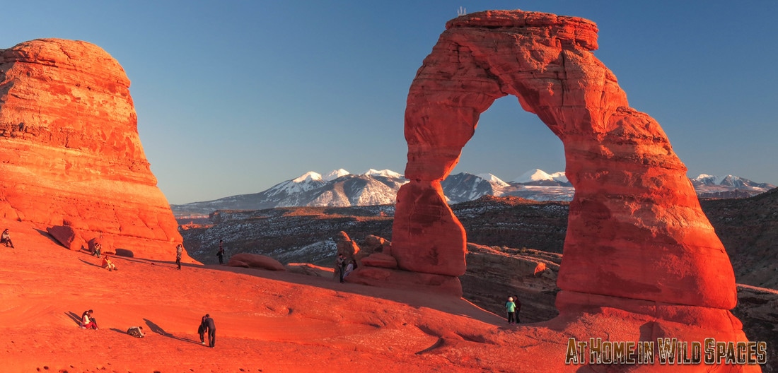
Arches National Park is easily dwarfed by most U.S. national parks, but it's quickly becoming one of the most popular in the park system. The chief attractions here are the park's puzzling, even gravity defying sandstone arches, numbering more than 2000, making Arches National Park is the greatest concentration of stone arches to be found anywhere in the world.
And of all these arches: one is more recognizable than the others – named for its precarious stature, Delicate Arch has become the unofficial symbol of the state of Utah. Originally called Cowboy Chaps Arch, the parks most famous formation was not included in the original 1929 monument. It would take nine more years before then Arches National Monument, would be expanded to include what has become its most famous feature.
But why has Delicate Arch garnered so much attention? It’s far from the park’s largest Arch, and it’s definitely not the park’s most accessible landmark.
There’s perhaps more than one correct answer, but if you’ve ever hiked the 3-mile trail to Delicate Arch then you know there is something incredibly unique about not just the arch, but the setting as well.
| Reaching Delicate Arch is almost like walking into a theater mid-play to find the star player on center stage performing for a captive audience. The arch itself sits on the edge of a breathtaking natural amphitheater, which seems too perfect and picturesque a setting to be a mere accident of Nature. | 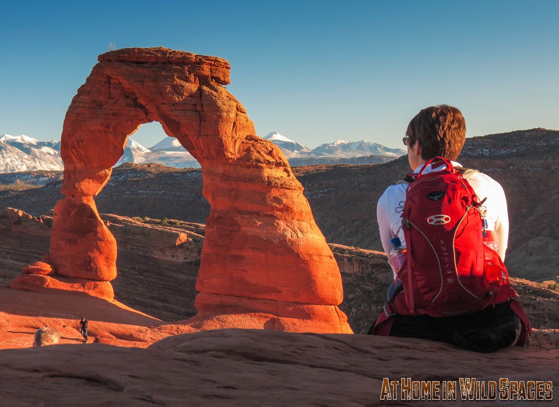 |
It's easy to imagine Mother Nature put a little extra effort into creating this masterpiece. Combined with the sprawling red rock deserts, forested foothills and 12,000 foot+ La Sal Mountains of the greater Moab landscape, the view of Delicate Arch is as wondrous a sight as any we’ve encountered.
It really has to be seen to be believed. Pictures, no matter how stunning, will simply never do the experience justice. If you want to truly understand why Delicate Arch has become one of the world most recognizable wonders, you'll have to see it for yourself. So here’s what you need to know before hiking to Delicate Arch:
It really has to be seen to be believed. Pictures, no matter how stunning, will simply never do the experience justice. If you want to truly understand why Delicate Arch has become one of the world most recognizable wonders, you'll have to see it for yourself. So here’s what you need to know before hiking to Delicate Arch:
Plan Ahead
Arches National Park is über popular these days, some might even say too popular. Crowds have become a mainstay of a visit to Delicate Arch, but there is still much you can do to avoid the huddled masses at Delicate Arch.
First, avoid holidays, free days and weekends if possible. A free day may sound like a bargain, but believe me, your much better off planning a visit during the off-season or on a weekday and paying the full $25 entrance fee. Arches National Park is even contemplating offering an off-season discount in order to alleviate the pressure of the summer crowds. If you are able, plan to visit when others can’t. The extra effort will be well worth your time.
Safety
The hike to Delicate Arch is far from dangerous, except for when people get careless. Summer temperatures in Arches frequently exceed 100 degrees Fahrenheit. Make sure you have adequate water and sun protection.
Ensure you and those in your party are fit enough for this short, albeit moderately challenging hike. From the Delicate Arch trailhead you’ll gain more than 600 feet without a break until shortly before reaching the arch. In high temperatures, 600 feet can feel like a lot more. Make sure to pace yourself.
Along with the elevation gain comes more than a few steep drop offs. The trail offers plenty of space to avoid any perilous cliffs, but you’ll almost certainly want to wander around and get a better view. Just mind your step, stay alert and make sure to watch any children you may be traveling with very closely.
Leave No Trace
Arches faces a number of challenges in the wake of its growing popularity. Vandalism, and environmental degradation are at the top of the list. Do your part to protect this unique place. Report any vandalism you witness to a park ranger, pack everything out, and never stray from official park trails, bare sandstone and dry washes.
Enjoy
The Hike to Delicate Arch is a treat, capped by a truly stunning view. Be courteous to others and enjoy your visit to Arches National Park.
Are you ready for a classic Halloween tradition with a Wild Spaces twist? Try carving Delicate Arch, Half Dome or Great Fountain Geyser into your jacko-lantern this season.
What you'll need:
-Fresh Pumkin
-Pattern (download below)
-Sharp Knife
-Exacto Knife
-Pins
-Metal Spoon (for scraping)
-Adult Supervision
-Patience
-Fresh Pumkin
-Pattern (download below)
-Sharp Knife
-Exacto Knife
-Pins
-Metal Spoon (for scraping)
-Adult Supervision
-Patience
|
|
| ||||||
It's essential to find a moist, fresh pumpkin. The dryer and more brittle your pumpkin the harder it will be to carve these patterns. Begin by cutting a lid in the top of your pumpkin about 4-5 inches in diameter. Then scrape the innards out of your pumpkin until the inside walls are clean.
Cut along the dotted lines on the pattern, overlap and pin sections to the pumpkin until flush against the surface of the pumpkin. Then use a poker/nail/thick needle and poke holes along every line on your pattern. The more holes you poke, the easier it will be to see the pattern on the pumpkin's surface when you remove the pattern.
Once you've finished poking along the lines, use the Exacto knife to shave the skin from the areas marked as light gray on the pattern. Once you've finished shaving all light grey areas revealing the flesh of the pumpkin, use your spoon to scrape the pumpkin's inner wall until the section with your carving is about half an inch thick.
Then using your Exacto knife cut out all areas marked as white on the pattern beginning with the smallest and ending with the largest. Once finished, light one or more candles and place them inside the pumpkin and you're finished.
If you'd like to see more National Park Jack-o-lantern patterns, then share this post. If we see strong demand for more we'll publish a book in time for Halloween 2017.
For more fun content make sure to follow us on Youtube, Facebook, Flickr and Instagram!
Ten Epic Hikes
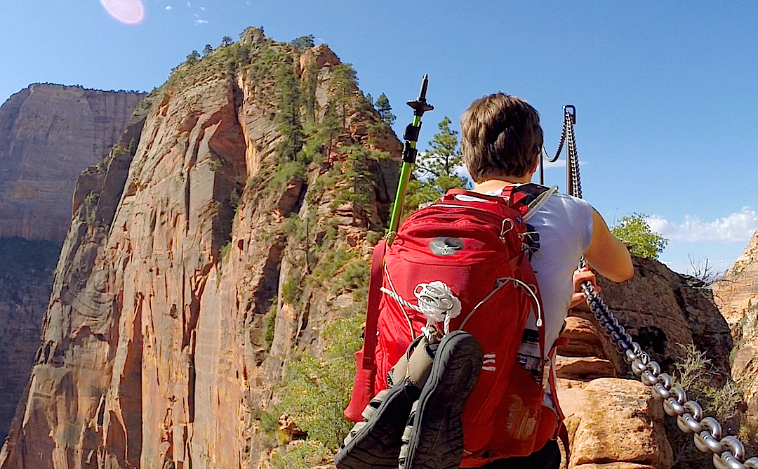
This year the National Park Service is celebrating its centennial. For 100 years the Park Service has been educating visitors on the history and natural treasures preserved by our national parks and inspiring each of us to both enjoy and protect these special places.
With Memorial Day weekend upon us, and many of us either visiting or making plans to visit one of our many amazing national parks - the team from At Home in Wild Spaces wanted to share ten of our favorite national park trails with you and invite you to tread lightly, Leave No Trace and enjoy getting outdoors this summer!
Some of these trails are quite popular. Click here to learn more about trail etiquette and safety. Happy Memorial Day everybody!
Zion NAtional Park
The Zion Narrows
Difficulty: Easy to Strenuous
Length: 1 to 16 miles
Trailhead: Temple of Sinawava or Chamberlain's Ranch (Permit Required)
Important Info: Contact Zion Visitor Information regarding flowrate and flash flood warnings before entering the Narrows. Wear closed toed shoes and bring a walking stick. Plan on getting wet: most of the trail is in the river. No trash or bathrooms along trail. Pack everything out with you. Be courteous of others this is a very popular trail. For more information click here.
Angels Landing
Difficulty: Strenuous
Length: 5.4 miles
Trailhead: Grotto Picnic Area
Important Info: Steep cliffs. Not appropriate for children. Hot during summer months pack water and sun protection. Be courteous of others on the trail. Outhouse at Scout lookout. For more information click here.
Length: 5.4 miles
Trailhead: Grotto Picnic Area
Important Info: Steep cliffs. Not appropriate for children. Hot during summer months pack water and sun protection. Be courteous of others on the trail. Outhouse at Scout lookout. For more information click here.
Olypmic National Park
Hoh Rainforst River Trail
Difficulty: Easy to Strenuous
Length: Up to 33 miles
Trailhead: Hoh Rainforest Visitor Center
Important Info: Rain likely most of the year (hence the title rainforest). Trail can be slick and muddy. Stay on trail and clear of steep river banks and drop offs. Check forecast before venturing out and plan accordingly. For more information click here.
Sol Duc FAlls
Difficulty: Easy
Length: 1.6 miles
Trailhead: Near Sol Duc Hot Springs (look for sign)
Important Info: Rain likely most of the year. Trail can be slick and muddy. Stay on trail and clear of steep river banks and drop offs. Check forecast before venturing out and plan accordingly. For more information click here.
Length: 1.6 miles
Trailhead: Near Sol Duc Hot Springs (look for sign)
Important Info: Rain likely most of the year. Trail can be slick and muddy. Stay on trail and clear of steep river banks and drop offs. Check forecast before venturing out and plan accordingly. For more information click here.
Bryce Canyon National Park
Queen's Garden/Navajo trail loop
Difficulty: Moderate
Length: 3 miles
Trailhead: Sunrise or Sunset Points
Important Info: Sun exposure and hot temperatures in summer. Bring plenty of water and sun protection. Be courteous of others on trail, stay away from cliffs and drop offs. No bathrooms or water available on trail. For more information click here.
Length: 3 miles
Trailhead: Sunrise or Sunset Points
Important Info: Sun exposure and hot temperatures in summer. Bring plenty of water and sun protection. Be courteous of others on trail, stay away from cliffs and drop offs. No bathrooms or water available on trail. For more information click here.
Thunder Mountain
Difficulty: Strenuous
Length: 7 to 14 miles
Trailhead: Red Canyon Visitor Center or Coyote Hollow Parking
Important Info: NOT WITHIN BRYCE CANYON NATIONAL PARK. Mountain biking is prohibited inside the National Park. The Thunder Mountain trail is located a few miles west of the park entrance along highway 12. 14 mile loop includes Red Canyon bike path. 7 mile requires shuttle arrangements. Hot in summer, no water or bathrooms on trail. Bring plenty of water and sun protection. Know your limits. For more info click here.
Yellowstone National Park
Uncle Tom's Trail
Difficulty: Moderate
Length: Less than 1 mile
Trailhead: Artist Point Parking Area
Important Info: Trail includes switchbacks on steep slopes and more than 300 steel stairs. Stay on trail, and make sure you are up for the climb back up from the bottom. Yellowstone is prime bear country. Click here for important information on bear safety click here. Be courteous of others on the trail. Bathrooms available in parking area. For more information click here.
Mystic falls
Difficulty: Easy
Length: 2.4 miles
Trailhead: Biscuit Basin (West side of boardwalk)
Important Info: Seasonal closures. Opens late May. This is bear country. For important information on safety while hiking in bear country click here. Stay on trail. Bathrooms available in parking area. For more information click here.
Arches National Park
Devil's Garden (Main Trail)
Difficulty: Easy to Moderate
Length: Up to 7.2 miles (Main and Primitive Trails combined)
Trailhead: Devils Garden Parking Area
Important Info: Can be very hot in summer. Pack plenty of water and sun protection. Stay on trail. The soil in much of the American Southwest and in Arches in particular is very delicate. Do not stray from established trails, dry washes or bare rock. Climbing or walking on/over arches is prohibited. Be courteous of others. For more information click here.
Devils Garden (Primitive Trail)
Difficulty: Moderate to Strenuous
Length: Up to 7.2 miles
Trailhead: Devil's Garden Parking Area
Important info: Exposure and high temperatures in summer. Pack enough water (one liter per hour) and adequate sun protection. Be courteous of others on the trail. The "primitive" section of Devils Garden requires more clamoring over obstacles than the "main" trail. Know your limits and be safe. Do not stray from official trails, dry washes or bare rock. The soil in Arches National Park is uniquely delicate. Climbing or walking on/over arches is prohibited. For more information click here.
Wild Spaces
News Feed
Everything from featured destinations and activities, insider info and traveling tips as well as current events.
Follow for more great content and start getting the most out of your Wild Spaces Adventures.
Archives
October 2023
September 2019
August 2019
May 2018
January 2018
May 2017
April 2017
October 2016
May 2016
April 2016
February 2016
January 2016
December 2015
November 2015
October 2015
September 2015
August 2015
May 2015
Categories
All
A Little Perspective
Arches National Park
Bears Ears
Bryce Canyon National Park
Conservation
Fact Checking
Fall
Featured Destination
Grand Canyon
Grand Staircase Escalante
Grand Staircase-Escalante
Halloween
Hiking
Hiking Guide
Jacko-lantern Patterns
Lists
Mt. Rainier
Must See
National Parks
Olympic National Park
Spring Time
Trails
Utah
What Is Wilderness
Yellowstone
Yosemite
Zion National Park

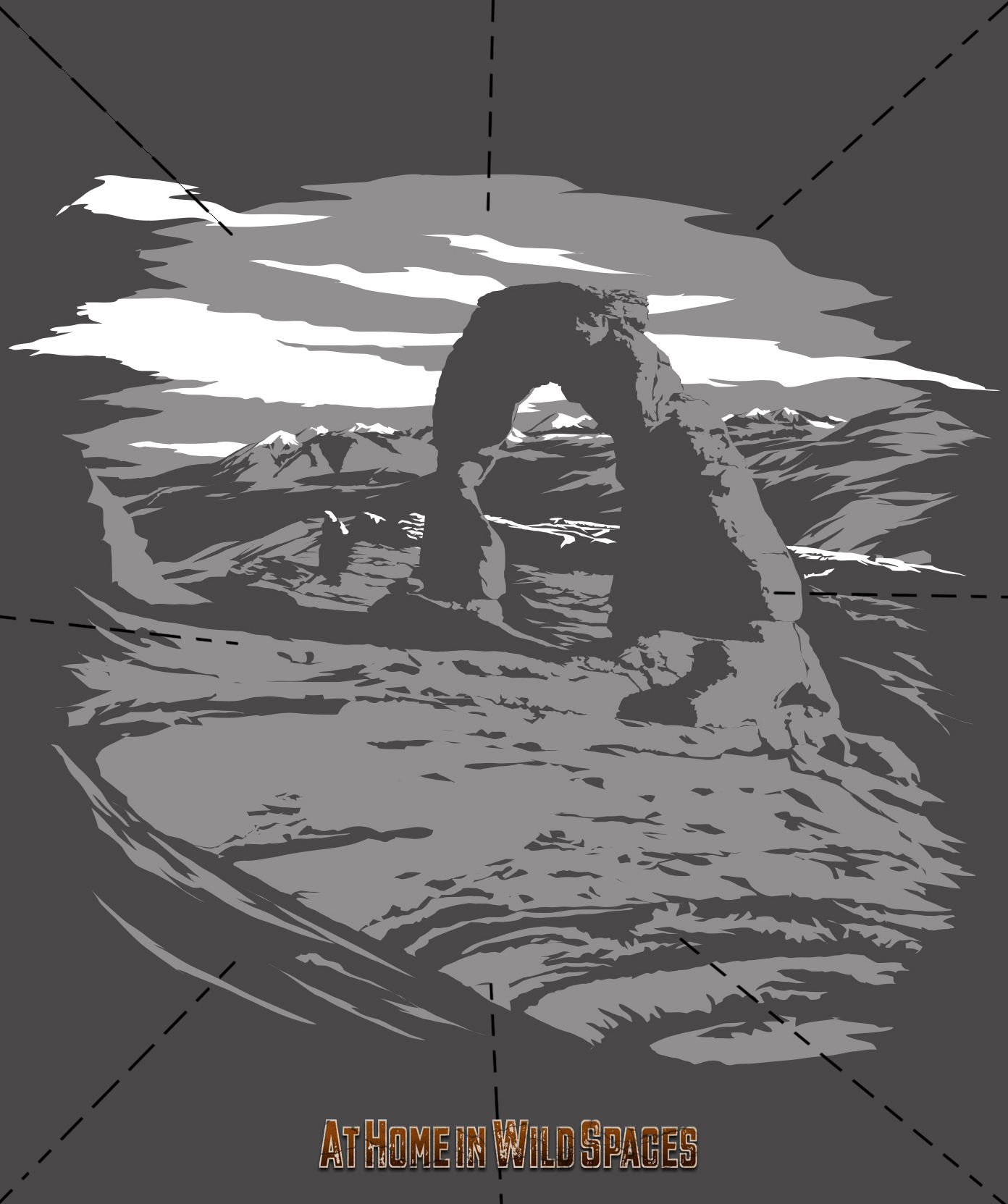